 click image to preview
activate zoom
click image to preview
activate zoom
Jual Murah” TRIMBLE R3 GPS GEODETIC/ GNSS
| Stok | Tersedia |
| Kategori | GPS |
Jual Murah” TRIMBLE R3 GPS GEODETIC/ GNSS
Suplier Alat Metal Detector Beragam tipe yang memudahkan pekerjaan Anda/perusahaan dengan harga yang sangat terjangkau dan kompetitif. Sistem GPS Trimble® R3 adalah solusi pascaproses GPS L1 lengkap dari pemimpin industri dalam teknologi survei GPS. Menggabungkan penerima dan antena GPS L1, pengontrol genggam yang kokoh, serta perangkat lunak lapangan dan perkantoran yang mudah digunakan, sistem Trimble R3 menghadirkan kontrol subsentimeter yang tepat ke lokasi Anda, menetapkan kontrol lokal baru, dan mengumpulkan data topografi. Sistem ini beroperasi tanpa saling berhadapan antar titik, dan dapat beroperasi siang atau malam dalam cuaca apa pun. Sistem GPS Trimble R3 menawarkan: Faktor bentuk unik yang bekerja sekeras Anda Perangkat lunak yang familier dan mudah digunakan di lapangan dan kantor Solusi survei total untuk GPS L1 Spesifikasi kinerja : Pengukuran • 12 Saluran L1 C/ A Code, L1 Full Cycle Carrier, WAAS/ EGNOS • Teknologi GPS Trimble Maxwell untuk pelacakan satelit yang tangguh • Trimble EVEREST™ teknologi reduksi multipath. Survei GPS Statis dan CepatStatis: Horizontal: ± ( 5 mm + 0,5 ppm) 2 RMS; Vertikal : ± ( 5 mm + 1 ppm) 2 RMS. Survei kinematik : Horizontal : ± ( 10 mm + 1 ppm) 2 RMS. Vertikal : ± ( 20 mm + 1 ppm) 2 RMS. Pemosisian Real-Time dengan WAAS/ EGNOS: Pemosisian diferensial WAAS/ EGNOS: biasanya akurat
Jual Murah” TRIMBLE R3 GPS GEODETIC/ GNSS
| Berat | 500 gram |
| Kondisi | Baru |
| Dilihat | 481 kali |
| Diskusi | Belum ada komentar |
Produk Terkait
Spesifikasi Spesifikasi: Tampilan & Performa: Dimensi satuan, P x P x T: 5,4″ P x 3,4″ T x 0,5″ P (13,8 cm x 8,7 cm x 1,3 cm) Ukuran layar, P x LP: 4,4″ P x 2,5″ T (11,1 x 6,3 cm); Diagonal 5 inci (12,7 cm) Resolusi layar, P x L: 800 x 480… selengkapnya
*Harga Hubungi CS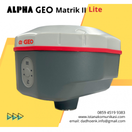
GNSS Alpa Geo Matrik II Lite GPS RTK GNSS Alpha Geo Matrix II Lite GNSS Alpha Geo MATRIX II Lite adalah perangkat GNSS generasi terbaru yang ringkas dan cerdas, dirancang untuk berbagai proyek survei dengan teknologi terkini. Sudut Kompensasi IMU Mode Jaringan >24 jam Perlindungan IP IP67 tahan debu Keterangan GNSS MATRIX II Lite –… selengkapnya
*Harga Hubungi CS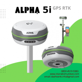
GPS Geodetik Alpha 5i | GPS RTK Alpha 5i RTK dengan dukungan semua sistem satelit dan semua pita bekerja dengan baik dengan kecepatan kalkulasi yang lebih tinggi. Ia mampu mendapatkan koneksi cepat, pengukuran cepat, pencarian satelit cepat, dan perbaikan cepat. Dilengkapi dengan sistem inersia presisi tinggi, transceiver radio jarak jauh baru yang terpasang, Alpha 5i… selengkapnya
*Harga Hubungi CS
Suplier Alat GPS Beragam tipe yang memudahkan pekerjaan Anda/perusahaan dengan harga yang sangat terjangkau dan kompetitif. Driver GNSS eXplorist Pro10 + EZSurv Kasar dan tahan air untuk kondisi ekstrim Kamera digital, speaker, dan mikrofon terintegrasi Konektivitas nirkabel Bluetooth ke perangkat berkemampuan Bluetooth Penyimpanan memori Kartu Micro SDHC yang dapat diperluas EZSurv Pasca-pemrosesan memungkinkan akurasi dan… selengkapnya
*Harga Hubungi CS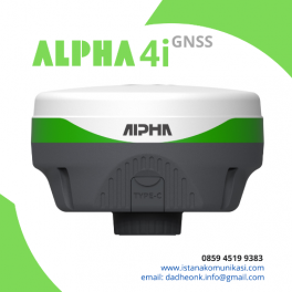
GPS Geodetik Alpha 4i GNSS | GPS RTK Dengan kerangka sistem terbaru dan SoC mesin pemosisian generasi terbaru, Alpha 4i melampaui batasan desain dan berhasil meringankan 50% beban surveyor global. Performanya luar biasa dan ukurannya sangat kecil Bahan Cangkang: Terbuat dari bahan nano dan penutup atas yang transparan, Alpha4i dilengkapi dengan rangka yang diperkuat paduan… selengkapnya
*Harga Hubungi CS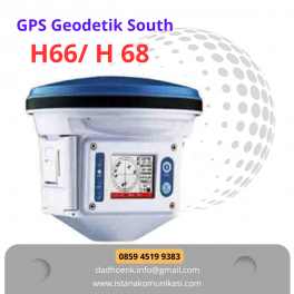
GPS Geodetic South H66/H68 Unit terintegrasi yang praktis, kompak dan kokoh, tersegel dengan baik untuk tahan air dan tahan debu Remote control nirkabel, nyaman untuk pengoperasian cerdas Baterai ganda yang dapat diganti secara otomatis untuk catu daya hingga 16 jam kerja Kekompakan tinggi, mampu bekerja dengan merek lain atau bahkan penerima frekuensi ganda untuk pengawasan… selengkapnya
*Harga Hubungi CS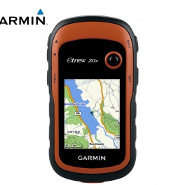
Suplier Alat GPS Beragam tipe yang memudahkan pekerjaan Anda/perusahaan dengan harga yang sangat terjangkau dan kompetitif. eTrex 20 mengambil salah satu perangkat genggam GPS paling populer dan andal serta menjadikannya lebih baik. Ergonomi yang didesain ulang, antarmuka yang lebih mudah digunakan, geocaching tanpa kertas, dan kemampuan pemetaan yang rumit menambah peningkatan serius pada perangkat GPS… selengkapnya
*Harga Hubungi CS
Suplier Alat GPS Beragam tipe yang memudahkan pekerjaan Anda/perusahaan dengan harga yang sangat terjangkau dan kompetitif. Sistem Spectra Precision® EPOCH® 50 GNSS, dengan 220 salurannya, memanfaatkan sinyal GPS L1/ L2/ L2C/ L5 dan GLONASS L1/ L2 secara efektif untuk jangkauan satelit yang luar biasa dan penentuan posisi yang tepat. EPOCH 50 menggunakan teknologi yang telah… selengkapnya
*Harga Hubungi CS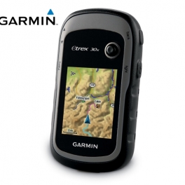
Spesifikasi Detail GPS Genggam, Kompas 3-sumbu: Resolusi dan Memori Lebih Baik Resolusi lebih besar dengan piksel tampilan 240 x 320 untuk meningkatkan keterbacaan Memori internal menampung untuk menampung lebih banyak peta Peta dasar seluruh dunia dengan relief berbayang Layar 2,2 inci, 65K warna , dapat dibaca di bawah sinar matahari 3- kompas sumbu dan altimeter… selengkapnya
*Harga Hubungi CS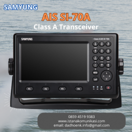
10%
Samyung Kelas A AIS SI-70A Samyung AIS SI-70A merupakan radio komunikasi laut (peralatan laut) Automatic Identification System atau disingkat AIS class A Transceiver dengan sistem penyiaran radio Frekuensi Sangat Tinggi (VHF) yang mengirimkan paket data melalui VHF Data Link (VDL) dan memungkinkan kapal yang dilengkapi AIS dan stasiun berbasis pantai untuk mengungkap informasi dan navigasi… selengkapnya
Rp 45.000.000 Rp 50.000.000
Belum ada komentar, buka diskusi dengan komentar Anda.