 click image to preview
activate zoom
click image to preview
activate zoom

GPS Geodetik RTK CHCnav i50
| Stok | Tersedia |
| Kategori | GPS |
GPS Geodetik RTK CHCnav i50
GPS Geodetik CHC I50 GNSS menghadirkan kecepatan dan akurasi dalam satu solusi GNSS yang mudah digunakan untuk menyelesaikan survei dan proyek konstruksi Anda secara efisien. Dikombinasikan dengan perangkat lunak lapangan CHCNAV LandStar 7 dan pengontrol Android HCE320, i50 adalah solusi survei yang sempurna untuk tugas penentuan posisi topografi dan konstruksi.
Fitur GPS Geodetik CHC I50 GNSS :
634 Saluran Konektivitas GNSS Penuh yang Diperluas
Mode Kerja Fleksibel Kekuatan Ekstra
yang Kuat dan Ringkas
Spesifikasi GPS Geodetik CHC I50 GNSS :
UMUM
Jenis Tanah
Tahun perkenalan awal 2018
Tinggi [m] 0,106
Kedalaman [m] 0,14
Lebar [m] 0,13
Berat total [kg] 1,29
KEKUATAN
Daya pengoperasian: min. [V] 7.4
Daya pengoperasian: maks. [V] 36
Konsumsi umum [W] 4.2
Catu daya internal 7.4
Catu daya eksternal 9 – 36
Waktu pengoperasian dengan catu daya internal [jam] 12
Sertifikasi CE
LINGKUNGAN
Suhu pengoperasian: mnt. [°C] -40
Suhu pengoperasian: maks. [°C] 65
Ketahanan kelembaban 95%
Tahan air, pasir dan debu IP67
Tahan guncangan dan getaran jatuh tiang 2 meter
Jual GPS Geodetik RTK CHCnav i50 dan cari produk terbaik lainnya, Gratis biaya pengiriman untuk wilayah Jakarta-Tangerang dan dapat dikirim ke seluruh Indonesia.
GPS Geodetik RTK CHCnav i50
| Berat | 1500 gram |
| Kondisi | Baru |
| Dilihat | 541 kali |
| Diskusi | Belum ada komentar |
Produk Terkait
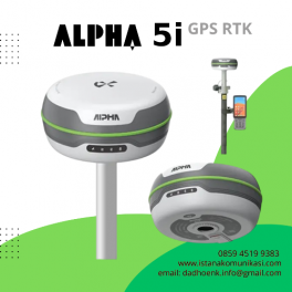
GPS Geodetik Alpha 5i | GPS RTK Alpha 5i RTK dengan dukungan semua sistem satelit dan semua pita bekerja dengan baik dengan kecepatan kalkulasi yang lebih tinggi. Ia mampu mendapatkan koneksi cepat, pengukuran cepat, pencarian satelit cepat, dan perbaikan cepat. Dilengkapi dengan sistem inersia presisi tinggi, transceiver radio jarak jauh baru yang terpasang, Alpha 5i… selengkapnya
*Harga Hubungi CS
Suplier Alat GPS Beragam tipe yang memudahkan pekerjaan Anda/perusahaan dengan harga yang sangat terjangkau dan kompetitif. GPS Trimble Geo XT 3000 Platform GPS total Anda untuk pengumpulan data lapangan Perangkat genggam Trimble® GeoXTâ„¢ dari seri GeoExplorer® 3000 adalah alat penting untuk memelihara GIS Anda.Penerima GPS berperforma tinggi dikombinasikan dengan komputer genggam yang kokoh, perangkat genggam… selengkapnya
*Harga Hubungi CS
Suplier Alat GPS Beragam tipe yang memudahkan pekerjaan Anda/perusahaan dengan harga yang sangat terjangkau dan kompetitif. eXplorist Pro10 dengan EZTagCE Kasar dan tahan air untuk kondisi ekstrim Kamera digital, speaker, dan mikrofon terintegrasi Konektivitas nirkabel Bluetooth ke perangkat berkemampuan Bluetooth Penyimpanan memori Kartu Micro SDHC yang dapat diisi Perangkat lunak EZTag CE dengan pengambilan dan… selengkapnya
*Harga Hubungi CS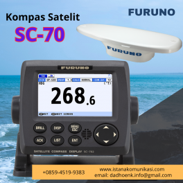
FURUNO LISTRIK CO, LTD. Menyediakan alat-alat produk Kelautan Pembentukan dan komersialisasi pencari ikan praktis Pada tahun 1938, Kiyotaka Furuno mendirikan FURUNO ELECTRIC SHOKAI LTD., pendahulu dari FURUNO ELECTRIC CO., LTD. Saat mengerjakan pekerjaan perlengkapan elektronik di kapal, dia merasakan dorongan yang kuat untuk memodernisasi perikanan, yang kemudian mendorongnya untuk mengembangkan alat pencari ikan. Dia berhasil… selengkapnya
*Harga Hubungi CS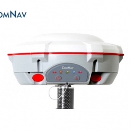
ComNav T300 GNSS RTK Dengan pengalaman puluhan tahun dalam survei receiver GNSS RTK, T300 adalah produk yang menggabungkan banyak keunggulan yang telah terbukti di pasaran. Itu dapat melacak semua konstelasi GNSS yang berfungsi. Dengan menggunakan teknologi algoritma QUAN TM unik ComNav , ia dapat berfungsi dalam mode RTK dengan semua konstelasi GNSS atau dengan menggunakan… selengkapnya
*Harga Hubungi CS
Suplier Alat Metal Detector Beragam tipe yang memudahkan pekerjaan Anda/perusahaan dengan harga yang sangat terjangkau dan kompetitif. Sistem GPS Trimble® R3 adalah solusi pascaproses GPS L1 lengkap dari pemimpin industri dalam teknologi survei GPS. Menggabungkan penerima dan antena GPS L1, pengontrol genggam yang kokoh, serta perangkat lunak lapangan dan perkantoran yang mudah digunakan, sistem Trimble… selengkapnya
*Harga Hubungi CS
Suplier Alat GPS Beragam tipe yang memudahkan pekerjaan Anda/perusahaan dengan harga yang sangat terjangkau dan kompetitif. Driver GNSS eXplorist Pro10 + EZSurv Kasar dan tahan air untuk kondisi ekstrim Kamera digital, speaker, dan mikrofon terintegrasi Konektivitas nirkabel Bluetooth ke perangkat berkemampuan Bluetooth Penyimpanan memori Kartu Micro SDHC yang dapat diperluas EZSurv Pasca-pemrosesan memungkinkan akurasi dan… selengkapnya
*Harga Hubungi CS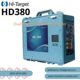
Spesifikasi Echosounder Frekuensi Ganda HI-TARGET HD380 HD380 adalah echosounder frekuensi ganda yang frekuensinya dapat disesuaikan. Menggunakan teknologi VF terkini dan memberikan kemampuan merekam frekuensi tinggi dan rendah secara bersamaan. HD380 dapat dikonfigurasi dengan berbagai transduser dalam menawarkan frekuensi, transduser standar yang ditawarkan adalah 20 kHz (Frekuensi Rendah) dan 200 kHz (Frekuensi Tinggi) untuk memenuhi semua… selengkapnya
*Harga Hubungi CS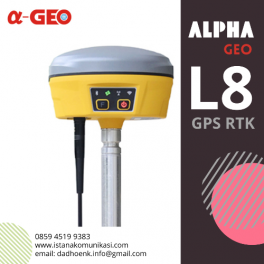
GPS Geodetik ALPHA GEO L8 GNSS Deskripsi GPS Alpha Geo L8 adalah receiver GPS GNSS multi-fungsi kelas atas, dengan mesin algoritma generasi baru dengan sistem operasi Linux, dilengkapi fitur untuk survei kemiringan, modul 4G serta radio bawaan, dan Bluetooth / Wi-Fi. Ini mengadopsi desain tampilan baru, struktur paduan magnesium, dan desain modul yang sangat terintegrasi…. selengkapnya
*Harga Hubungi CS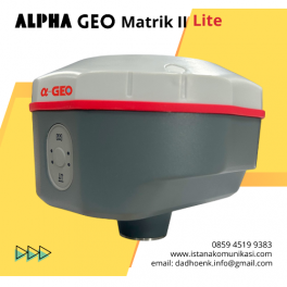
GNSS Alpa Geo Matrik II Lite GPS RTK GNSS Alpha Geo Matrix II Lite GNSS Alpha Geo MATRIX II Lite adalah perangkat GNSS generasi terbaru yang ringkas dan cerdas, dirancang untuk berbagai proyek survei dengan teknologi terkini. Sudut Kompensasi IMU Mode Jaringan >24 jam Perlindungan IP IP67 tahan debu Keterangan GNSS MATRIX II Lite –… selengkapnya
*Harga Hubungi CS
Belum ada komentar, buka diskusi dengan komentar Anda.