 click image to preview
activate zoom
click image to preview
activate zoom

Garmin GPSMap 620
| Stok | Tersedia |
| Kategori | GPS |
Garmin GPSMap 620
| Detil | Suplier Alat GPS Beragam tipe yang memudahkan pekerjaan Anda/perusahaan dengan harga yang sangat terjangkau dan kompetitif. Ikhtisar Menavigasi melalui darat dan laut dengan GPSMAP 620. Chartplotter kelautan berfitur lengkap ini melakukan tugas ganda dengan mode otomotif yang siap berangkat segera setelah Anda mencapai pantai saat dilengkapi dengan peta jalan opsional City Navigator® NT untuk Amerika Utara (dijual terpisah). Dan untuk memastikan Anda selalu mengetahui jalannya, GPSMAP 620 hadir sebagai standar dengan penerima GPS sensitivitas tinggi dan tampilan layar sentuh resolusi tinggi yang cemerlang.
Kuat dan PortabelDilengkapi mode kelautan dan otomotif, penerima GPS sensitivitas tinggi, dan casing kokoh dengan desain tahan air (IPX7), GPSMAP 620 siap untuk perjalanan Anda berikutnya. 620 dengan mudah berpindah gigi antara mode kelautan dan otomotif. Jika didukung oleh mount kelautan, Anda akan memiliki akses sekilas ke data kelautan Anda. Dan ketika digunakan dengan dudukan otomotif opsional dan data peta City Navigator NT untuk Amerika Utara, mode otomotif secara otomatis diaktifkan dan GPSMAP 620 menjadi navigator jalan yang tangguh. Dirancang untuk BersinarDengan tampilan layar sentuh WVGA 5,2″ (13,21 cm) yang cemerlang dan antarmuka yang intuitif, Anda akan memiliki semua yang Anda perlukan untuk bernavigasi dengan percaya diri. GPSMAP 620 dilengkapi dengan peta dasar satelit seluruh dunia untuk citra “pemandangan dari luar angkasa” berupa garis pantai dan fitur permukaan lainnya di wilayah tersebut. Melalui lautDalam mode kelautan, GPSMAP 620 menyediakan tampilan 3-D MarinerEye di atas permukaan air, tampilan FishEye di bawah permukaan air, dan teknologi Auto Guidance yang mencari data grafik untuk menyarankan jalur terbaik dengan data BlueChart® g2 Vision ® opsional (dijual terpisah). Dan Anda akan selalu mendapatkan gambaran besarnya dengan peta dasar seluruh dunia yang menjadi standar pada GPSMAP 620. GPSMAP 620 juga mematuhi NMEA 0183, sehingga dapat dengan mudah ditambahkan ke jaringan kelautan yang ada. Dan dengan akses ke peta penangkapan ikan, data pasang surut dan arus, layanan kelautan, jalan pesisir, dan lainnya melalui data opsional BlueChart® g2 Vision, Anda akan selalu mendapat informasi saat berada di perairan. Melalui DaratDalam mode otomotif, GPSMAP 620 memberikan petunjuk arah belokan demi belokan yang menyebutkan nama jalan (dengan data City Navigator NT yang diperlukan untuk Amerika Utara). Dan perencanaan rute tidak pernah semudah ini. Baik Anda sedang mencari toko perahu atau toko umpan, Anda akan dapat merencanakan rute tercepat dan paling efisien. Anda juga dapat membuat tempat menarik khusus dan mengatur peringatan jarak untuk memberi tahu Anda apa yang ada di jalur Anda saat melakukan perjalanan. |
|---|---|
| Spesifikasi | Spesifikasi
Penampilan fisikDimensi unit, LxTxD 5,9″W x 4″H x 1,9″D (15,0 x 10,2 x 4,8 cm) Ukuran layar, WxH 4,5″W x 2,7″H (11,4 x 6,9 cm); Diag 5,2″ (13,2 cm) Resolusi layar, LxT 800 x 480 piksel Tipe layar WVGA Berat 17,3 ons (490,4 g) Baterai lithium-ion yang dapat diisi ulang Daya tahan baterai hingga 9 jam Tahan air Ya (IPX7) Penerima sensitivitas tinggi Ya Antena internal Input/output NMEA NMEA 0183 Konsumsi daya 0,6A pada 12V; 0,3A pada 24V Peta & MemoriPeta dasar Ya Peta yang dimuat sebelumnya Tidak Kemampuan untuk menambahkan peta Ya Solid state internal memori internal Menerima kartu data Slot kartu SD™ Titik arah/favorit/lokasi 1500 (mode kelautan); 1000 (mode otomotif) Rute 50 (mode kelautan); 10 (mode otomotif) Track log 10.000 poin, 20 track tersimpan (mode kelautan); 10.000 poin, tidak ada trek yang disimpan (mode otomotif) Fitur & ManfaatKompatibel dengan radar Garmin Tidak kompatibel dengan sonar Garmin Tidak kompatibel dengan Garmin Marine Network™ Tidak kompatibel dengan Layar Sentuh Ya Mendukung AIS (melacak posisi kapal target) Ya Mendukung DSC (menampilkan data posisi dari radio VHF berkemampuan DSC) Ya Alarm yang dapat didengar Ya Tabel pasang surut Ya Berburu/memancing kalender Tidak Ada informasi matahari dan bulan Ya Tampilan peta 3-D Ya (dengan kartu BlueChart g2 Vision opsional) Panduan Otomatis Ya (dengan kartu BlueChart g2 Vision opsional) XM WX Cuaca & Radio untuk kompatibel dengan AS & Kanada Tidak Perutean otomatis (perutean belokan demi belokan di jalan raya) Ya (dengan pemetaan opsional untuk detail jalan) Perintah suara (misalnya “Belok kanan dalam jarak 500 kaki†) productTemplate.tab.specs.picklist.yes_(with_optional_mapping_for_detailed_roads_mount) Mengucapkan nama jalan (misalnya “Belok kanan ON ELM STREET dalam jarak 500 kaki†) Ya (dengan pemetaan opsional untuk detail jalan) Jack headphone/saluran audio audio Ya Input/output audio/video Tidak Portabel Ya Ramah otomotif/sepeda motor Ya |
Tags: Garmin 620, Garmin GPSMap, Garmin GPSMap 620, Garmin Indonesia, GPSMap 620
Garmin GPSMap 620
| Berat | 300 gram |
| Kondisi | Baru |
| Dilihat | 575 kali |
| Diskusi | Belum ada komentar |
Produk Terkait
Suplier Alat Survey Beragam tipe yang memudahkan pekerjaan anda/perusahaan dengan harga yang sangat terjangkau dan kompetitif. Dapatkan trackplotting berkualitas dengan GPS 152H sensitivitas tinggi, trackplotter skala abu-abu dengan fitur yang mudah digunakan sesuai dengan perahu dan anggaran Anda. Dapatkan Satelit dengan Cepat GPS 152H dilengkapi dengan penerima GPS sensitivitas tinggi, antena GPS internal, dan konektor… selengkapnya
*Harga Hubungi CS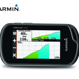
Suplier Alat GPS Beragam tipe yang memudahkan pekerjaan Anda/perusahaan dengan harga yang sangat terjangkau dan kompetitif. Deskripsi : GPS Garmin Oregon 600 Lebih Banyak Fitur, Lebih Banyak Kekuatan Satelit Di Balik Layar Sentuh Terberat dan Terang kami Tampilan layar sentuh 3″ yang dapat dibaca di bawah sinar matahari dengan orientasi ganda Kompas 3 sumbu dengan… selengkapnya
*Harga Hubungi CS
Kelas B AIS-50N Chartpotter AIS 50N Samyung adalah perangkat Automation Identification System (AIS) yang berfungsi untuk menghubungkan dan melacak kapal secara real-time. Perangkat ini memiliki tampilan berwarna yang dapat menampilkan peta laut, posisi kapal, informasi kapal sekitar, dan kedalaman laut. AIS 50N Samyung umumnya digunakan untuk kapal ikan dan kapal di bawah 300GT. Memberikan manfaat… selengkapnya
*Harga Hubungi CS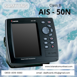
AIS samyung 50N Class B AIS Chartplotter yang ada di eurotek sudah dilengkapi dengan peta dunia serta menggunakan NAVIONICS GOLD pada kartu SD serta tampilan navigasi yang real time yang akurat. Grafik elektroniknya sudah terupdate dan tersedia. Ditambah peta bawaan dengan jangkauan cincin dan 12 zoom sekitar 0,01-32 nm, Modus kursor ID memungkinkan mudah membaca… selengkapnya
*Harga Hubungi CS
Suplier Alat GPS Beragam tipe yang memudahkan pekerjaan Anda/perusahaan dengan harga yang sangat terjangkau dan kompetitif. Solusi Rover All-in-one untuk Jaringan RTK ProMark 200 adalah rover RTK jaringan frekuensi ganda yang paling hemat biaya. Solusi ProMark 200 mencakup receiver GNSS Ashtech baru yang kokoh yang menjalankan sistem operasi Windows Mobile® 6.5, perangkat lunak lapangan Ashtech… selengkapnya
*Harga Hubungi CS
Garmin GPSMap 78S berkemampuan kedap air standar IPX7 dan mengapung di air. Ini cocok untuk pelaut dan penggemar olahraga air yang ingin beraktivitas dengan perangkat terbaik, GPSMap 78S yang kuat memiliki fitur pemetaan warna yang tajam, unit penerima dengan sensitivitas tinggi, pegangan sisi karet baru yang dibeuntuk, juga dilengkapi slot kartu microSD untuk memuat peta… selengkapnya
*Harga Hubungi CS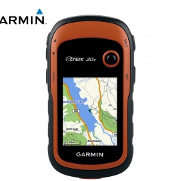
Suplier Alat GPS Beragam tipe yang memudahkan pekerjaan Anda/perusahaan dengan harga yang sangat terjangkau dan kompetitif. eTrex 20 mengambil salah satu perangkat genggam GPS paling populer dan andal serta menjadikannya lebih baik. Ergonomi yang didesain ulang, antarmuka yang lebih mudah digunakan, geocaching tanpa kertas, dan kemampuan pemetaan yang rumit menambah peningkatan serius pada perangkat GPS… selengkapnya
*Harga Hubungi CS
Suplier Alat Metal Detector Beragam tipe yang memudahkan pekerjaan Anda/perusahaan dengan harga yang sangat terjangkau dan kompetitif. Sistem GPS Trimble® R3 adalah solusi pascaproses GPS L1 lengkap dari pemimpin industri dalam teknologi survei GPS. Menggabungkan penerima dan antena GPS L1, pengontrol yang kokoh, serta perangkat lunak lapangan dan apartemen yang mudah digunakan, sistem Trimble R3… selengkapnya
*Harga Hubungi CS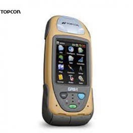
Suplier Alat GPS Beragam tipe yang memudahkan pekerjaan Anda/perusahaan dengan harga yang sangat terjangkau dan kompetitif. Topcon, perusahaan yang memberikan Anda receiver GPS terintegrasi pertama, kini menghadirkan kepada Anda receiver GNSS Genggam dan pengontrol lapangan pertama yang terintegrasi penuh! Desain Kecil & Ringan— pengembangan jaringan ideal yang Dapat Diskalakan & Dapat Diperluas— perangkat genggam atau… selengkapnya
*Harga Hubungi CS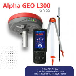
GPS Geodetik GNSS Alpha GEO L300 RTK L300 adalah GNSS Receiver GPS Geodetik RTK pintar generasi baru yang ringkas, dirancang untuk berbagai proyek survei dengan teknologi GNSS terbaru. Perangkat ini dilengkapi dengan semua modul konektivitas modern yang diperlukan, termasuk Bluetooth, radio internal, WiFi, dan modem 4G. Selain itu, L300 juga menggunakan teknologi terbaru seperti baterai… selengkapnya
*Harga Hubungi CS
Belum ada komentar, buka diskusi dengan komentar Anda.