 click image to preview
activate zoom
click image to preview
activate zoom

Garmin GPSMap 152Hi
| Stok | Tersedia |
| Kategori | GPS |
Garmin GPSMap 152Hi
Suplier Alat Survey Beragam tipe yang memudahkan pekerjaan anda/perusahaan dengan harga yang sangat terjangkau dan kompetitif. Dapatkan trackplotting berkualitas dengan GPS 152H sensitivitas tinggi, trackplotter skala abu-abu dengan fitur yang mudah digunakan sesuai dengan perahu dan anggaran Anda.
Dapatkan Satelit dengan CepatGPS 152H dilengkapi dengan penerima GPS sensitivitas tinggi, antena GPS internal, dan konektor BNC internal untuk koneksi antena eksternal opsional guna memastikan Anda memperoleh sinyal satelit dengan cepat, di mana pun posisi Anda. Ia juga dapat menerima koreksi posisi dari Wide Area Augmentation System (WAAS), yang menjadikan data penentuan posisi yang sudah akurat menjadi lebih andal. Faktanya, saat Anda mengaktifkan WAAS, Anda dapat meningkatkan pelaporan 152H hingga dalam jarak 3 m (9,84 kaki). menyimpan Lebih Banyak Data PentingDengan peningkatan memori, GPS 152H dapat menyimpan hingga 3.000 titik arah dan 50 rute. Dan layar kontras tinggi diagonal 4″ (10,16 cm) memudahkan untuk melihat dan menavigasi ke titik arah atau tempat lain. Kami juga menambahkan keluaran NMEA 0183 sehingga Anda dapat mengirim data posisi ke perangkat elektronik lain di kapal Anda. |
|
| Spesifikasi | SPESIFIKASI:
penampilan fisikDimensi unit, PxTxD : 5,3″ x 4,9″ x 2,4″ (13,4 x 12,5 x 6,1 cm) Ukuran layar, WxH : 3,5″ x 2,3â €³, 4,0″ diagonal (8,9 x 5,8 cm, diagonal 10,2 cm) Resolusi layar, LxT : 160 x 100 piksel Tipe layar : LCD skala abu-abu 4 tingkat Berat : 1 pon (454 g) Baterai : tidak ada Daya tahan baterai : tidak ada Tahan air : Ya (IPX7) Penerima sensitivitas tinggi : Ya Antena : input/output NMEA internal atau jarak jauh : NMEA 0183 Peta & MemoriPeta Dasar : Tidak Ada Peta yang dimuat : Tidak Ada Kemampuan untuk menambahkan peta : Tidak Memori internal : 1 MB Menerima kartu data : tidak ada Titik arah/favorit/lokasi : 3.000 Rute : 50 Log lintasan : 10.000 titik Fitur & ManfaatKompatibel dengan radar Garmin : Tidak kompatibel dengan sonar Garmin : Tidak kompatibel dengan Garmin Marine Network™ : Tanpa Layar Sentuh : Tidak Mendukung AIS (melacak posisi kapal target) : Tidak Mendukung DSC (menampilkan posisi data dari radio VHF berkemampuan DSC) : Tidak termasuk alarm : Ya Tabel pasang surut air laut : Tidak Ada kalender pencarian/ikan : Tidak Ada informasi matahari dan bulan : Ya Tampilan peta 3D : Tidak Panduan Otomatis : Tidak Dilengkapi dengan cuaca & Radio XM WX untuk AS & Kanada : Tidak Perutean otomatis (perutean menurun demi berkemah di jalan raya) : Tidak ada perintah suara (misalnya “Belok kanan dalam jarak 500 kaki†) : Tidak Mengucapkan nama jalan (misalnya “Belok kanan ON ELM STREET dalam jarak 500 kaki†): Tidak Ada jack headphone/saluran audio audio : Tidak Ada Audio /input/output video : Tidak Portabel : Tidak Ramah otomotif/sepeda motor : Tidak |
|---|
Tags: Garmin 152Hi, Garmin 152Hi Marine, Garmin GPSMap 152Hi, Garmin Indonesia, GPSMap 152Hi, GPSMap 152Hi Marine, GPSMap Marine
Garmin GPSMap 152Hi
| Berat | 500 gram |
| Kondisi | Baru |
| Dilihat | 456 kali |
| Diskusi | Belum ada komentar |
Produk Terkait
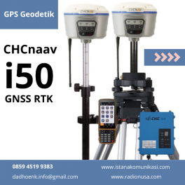
GPS Geodetik CHC I50 GNSS menghadirkan kecepatan dan akurasi dalam satu solusi GNSS yang mudah digunakan untuk menyelesaikan survei dan proyek konstruksi Anda secara efisien. Dikombinasikan dengan perangkat lunak lapangan CHCNAV LandStar 7 dan pengontrol Android HCE320, i50 adalah solusi survei yang sempurna untuk tugas penentuan posisi topografi dan konstruksi. Fitur GPS Geodetik CHC I50… selengkapnya
*Harga Hubungi CS
Suplier Alat Metal Detector Beragam tipe yang memudahkan pekerjaan Anda/perusahaan dengan harga yang sangat terjangkau dan kompetitif. Sistem GPS Trimble® R3 adalah solusi pascaproses GPS L1 lengkap dari pemimpin industri dalam teknologi survei GPS. Menggabungkan penerima dan antena GPS L1, pengontrol genggam yang kokoh, serta perangkat lunak lapangan dan perkantoran yang mudah digunakan, sistem Trimble… selengkapnya
*Harga Hubungi CS
Suplier Alat GPS Beragam tipe yang memudahkan pekerjaan Anda/perusahaan dengan harga yang sangat terjangkau dan kompetitif. Sistem Spectra Precision® EPOCH® 50 GNSS, dengan 220 salurannya, memanfaatkan sinyal GPS L1/ L2/ L2C/ L5 dan GLONASS L1/ L2 secara efektif untuk jangkauan satelit yang luar biasa dan penentuan posisi yang tepat. EPOCH 50 menggunakan teknologi yang telah… selengkapnya
*Harga Hubungi CS
Suplier Alat GPS Beragam tipe yang memudahkan pekerjaan Anda/perusahaan dengan harga yang sangat terjangkau dan kompetitif. GPS Trimble Juno SB Bekali kru Anda dengan komputer lapangan kompak dan tahan lama yang mengintegrasikan beragam fungsi, termasuk pengambilan foto dan penerima GPS hasil tinggi dengan akurasi posisi 2 hingga 5 meter secara real time atau pascaproses 1… selengkapnya
*Harga Hubungi CS
Suplier Alat GPS Beragam tipe yang memudahkan pekerjaan Anda/perusahaan dengan harga yang sangat terjangkau dan kompetitif. Solusi lapangan terbaik untuk manajemen aset dengan kemampuan suara dan data 3,5G Perangkat genggam Juno® SD adalah perangkat genggam yang tahan lama dan ringan yang mengintegrasikan serangkaian fitur canggih. Menyediakan data seluler terintegrasi dan kemampuan panggilan suara, pengambilan foto,… selengkapnya
*Harga Hubungi CS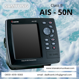
AIS samyung 50N Class B AIS Chartplotter yang ada di eurotek sudah dilengkapi dengan peta dunia serta menggunakan NAVIONICS GOLD pada kartu SD serta tampilan navigasi yang real time yang akurat. Grafik elektroniknya sudah terupdate dan tersedia. Ditambah peta bawaan dengan jangkauan cincin dan 12 zoom sekitar 0,01-32 nm, Modus kursor ID memungkinkan mudah membaca… selengkapnya
*Harga Hubungi CS
Suplier Alat GPS Beragam tipe yang memudahkan pekerjaan Anda/perusahaan dengan harga yang sangat terjangkau dan kompetitif. Solusi Rover All-in-one untuk Jaringan RTK ProMark 200 adalah rover RTK jaringan frekuensi ganda yang paling hemat biaya. Solusi ProMark 200 mencakup receiver GNSS Ashtech baru yang kokoh yang menjalankan sistem operasi Windows Mobile® 6.5, perangkat lunak lapangan Ashtech… selengkapnya
*Harga Hubungi CS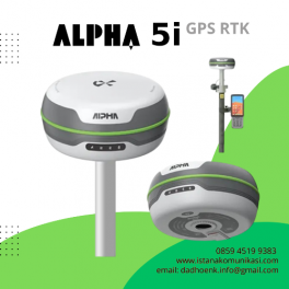
GPS Geodetik Alpha 5i | GPS RTK Alpha 5i RTK dengan dukungan semua sistem satelit dan semua pita bekerja dengan baik dengan kecepatan kalkulasi yang lebih tinggi. Ia mampu mendapatkan koneksi cepat, pengukuran cepat, pencarian satelit cepat, dan perbaikan cepat. Dilengkapi dengan sistem inersia presisi tinggi, transceiver radio jarak jauh baru yang terpasang, Alpha 5i… selengkapnya
*Harga Hubungi CS
Suplier Alat Metal Detector Beragam tipe yang memudahkan pekerjaan Anda/perusahaan dengan harga yang sangat terjangkau dan kompetitif. Leica Viva GS08plus membantu Anda menyelesaikan tugas pengukuran Anda. Cukup aktifkan dan koneksi dibuat ke jaringan referensi lokal Anda. Dengan dukungan penuh pesan transformasi RTCM 3.1, posisi secara otomatis diberikan dalam koordinat lokal. GS08plus siap diukur! Kami tahu… selengkapnya
*Harga Hubungi CS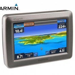
Detil Suplier Alat GPS Beragam tipe yang memudahkan pekerjaan Anda/perusahaan dengan harga yang sangat terjangkau dan kompetitif. Ikhtisar Menavigasi melalui darat dan laut dengan GPSMAP 620. Chartplotter kelautan berfitur lengkap ini melakukan tugas ganda dengan mode otomotif yang siap berangkat segera setelah Anda mencapai pantai saat dilengkapi dengan peta jalan opsional City Navigator® NT… selengkapnya
*Harga Hubungi CS
Belum ada komentar, buka diskusi dengan komentar Anda.