 click image to preview
activate zoom
click image to preview
activate zoom

Garmin GPS Map Oregon 650
| Stok | Tersedia |
| Kategori | GPS |
Garmin GPS Map Oregon 650
| Suplier Alat GPS Beragam tipe yang memudahkan pekerjaan Anda/perusahaan dengan harga yang sangat terjangkau dan kompetitif. Deskripsi :
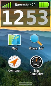
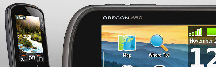
GPS Garmin Oregon 650 Lebih Banyak Fitur, Lebih Banyak Kekuatan Satelit di Balik Layar Sentuh yang Tangguh dan Cerah
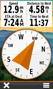
Foto BerkualitasAmbil foto berkualitas dengan kamera digital autofokus 8 MP bawaan Oregon 650. Setiap foto diberi tag geografis, memungkinkan Anda menavigasi kembali ke tempat yang tepat. Bagikan foto ke semua teman Anda melalui Garmin Adventures . Untuk penyimpanan lebih besar, masukkan kartu microSDâ„¢; Anda bahkan dapat melihat gambar dari perangkat lain pada kartu microSD dengan penampil gambar Oregon. Sentuh dan pergiOregon 650 memiliki teknologi layar reflektif untuk layar sentuh paling cemerlang yang dapat dibaca di bawah sinar matahari yang pernah kami buat. Warnanya terlihat jelas di bawah sinar matahari penuh dan di tempat teduh. Layarnya telah diperkuat agar tahan terhadap benturan namun tetap dapat mengakomodasi pengoperasian dengan sarung tangan. Dan dengan layar multisentuh berorientasi ganda, Anda tidak hanya melihat peta, Anda juga akan berinteraksi dengannya saat memperbesar, menggeser, dan memutar tampilan. Gandakan Kekuatan AndaOregon 650 menghadirkan sistem baterai ganda kami yang canggih. Anda akan memiliki pilihan untuk menggunakan paket NiMH yang dapat diisi ulang secara internal (disertakan) atau baterai AA tradisional — Paket NiMH mengisi daya saat perangkat terhubung ke daya eksternal. Dapatkan Arah AndaOregon 650 memiliki kompas elektronik 3 sumbu internal dengan kemiringan akselerometer untuk menunjukkan tujuan Anda bahkan saat berdiri diam, atau tidak menjaganya tetap rata. Altimeter barometriknya melacak perubahan tekanan untuk menentukan ketinggian Anda dengan tepat. Anda bahkan dapat menggunakannya untuk memplot tekanan barometrik dari waktu ke waktu untuk mengawasi perubahan kondisi cuaca. Dengan sensitivitas tinggi, receiver GPS berkemampuan WAAS dan GLONASS serta prediksi satelit HotFix®, Oregon 650 menemukan posisi Anda dengan cepat dan tepat, dan mempertahankan lokasi GPS bahkan di tempat yang tertutup rapat dan ngarai yang dalam. Bagikan Secara NirkabelDengan Oregon 650 Anda dapat berbagi titik jalan, jalur, rute, dan geocache hingga 50 kali lebih cepat dengan perangkat genggam Garmin nirkabel lainnya yang kompatibel. Plus, Anda juga dapat berbagi file besar seperti foto, Garmin Adventures, dan Custom Maps. Cukup sentuh “kirim†untuk mentransfer informasi Anda. Tambahkan PetaMenambahkan lebih banyak peta ke Oregon itu mudah. Muat peta TOPO US 24K dan ikuti jejaknya; tambahkan peta TOPO Trailhead Series dan jelajahi jalur terkenal seperti Appalachian Trail dan Pacific Crest Trail; pasang kartu BlueChart® g2 yang sudah dimuat sebelumnya untuk hari yang menyenangkan di atas air; atau memuat data peta City Navigator® untuk rute akselerasi demi akselerasi di jalan raya. Tambahkan gambar satelit ke peta Anda dengan BirdsEye Satellite Imagery (perlu berlangganan). Muat Semua GeocacheTidak perlu lagi memilih, memilih, dan merencanakan, cukup unduh semuanya. Oregon 650 dapat menampung hingga 4 juta. Unduh setiap cache di OpenCaching.com . Muat cache menggunakan program atau situs web favorit Anda yang mendukung file GGZ. Semua fitur geocaching tanpa kertas Anda akan tersedia untuk setiap cache. Baca deskripsi lengkap, petunjuk dan log. Lihat cache foto. Filter cache berdasarkan ukuran, medan, kesulitan dan jenis. Koneksi ke cache yang mendukung kicauan. Catat log Anda di lapangan. Lakukan semuanya. Rencanakan Perjalanan Anda BerikutnyaKendalikan petualangan Anda berikutnya dengan BaseCamp â„¢, perangkat lunak yang memungkinkan Anda melihat dan mengatur peta, titik jalan, rute, dan trek. Perangkat perencanaan perjalanan gratis ini bahkan memungkinkan Anda membuat Garmin Adventures yang dapat Anda bagikan dengan teman, keluarga, atau sesama penjelajahan. BaseCamp menampilkan data peta topografi dalam 2D atau 3D di layar komputer Anda, termasuk garis kontur dan profil ketinggian. Itu juga dapat mentransfer gambar satelit dalam jumlah tak terbatas ke perangkat Anda saat dipasangkan dengan Citra Satelit BirdsEye
 Kecerahan Layar Teknologi layar reflektif menggunakan cahaya eksternal, seperti sinar matahari, yang dikombinasikan dengan lampu latar LED perangkat untuk meningkatkan kecerahan dan tampilan. Selain itu, Anda menghemat daya dengan tidak perlu menyalakan lampu latar. Kecerahan Layar Teknologi layar reflektif menggunakan cahaya eksternal, seperti sinar matahari, yang dikombinasikan dengan lampu latar LED perangkat untuk meningkatkan kecerahan dan tampilan. Selain itu, Anda menghemat daya dengan tidak perlu menyalakan lampu latar. 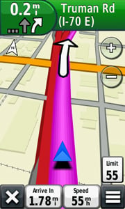 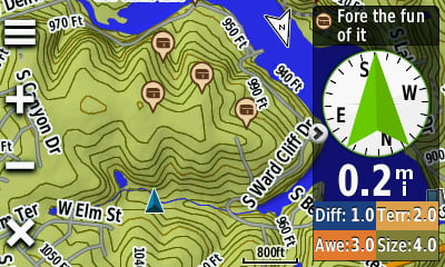 Orientasi Ganda Melihat peta dan data dalam mode potret atau lanskap. Mode lanskap sangat bagus untuk mengetik dan navigasi jalan. Orientasi Ganda Melihat peta dan data dalam mode potret atau lanskap. Mode lanskap sangat bagus untuk mengetik dan navigasi jalan. 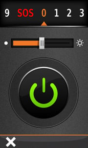 Senter Torch memiliki tingkat kecerahan tinggi dan rendah serta opsi strobo untuk menghemat daya baterai. Senter Torch memiliki tingkat kecerahan tinggi dan rendah serta opsi strobo untuk menghemat daya baterai. 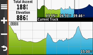 Tampilan Jalur Penuh Plot Ketinggian Tingkat Lanjut memungkinkan Anda melihat keseluruhan plot ketinggian dan dengan cepat memindahkan tampilan yang diperbesar ke tempat mana pun di plot. Plot Masa Depan menggunakan data pemetaan Anda untuk menunjukkan apa yang diharapkan di masa depan. Tampilan Jalur Penuh Plot Ketinggian Tingkat Lanjut memungkinkan Anda melihat keseluruhan plot ketinggian dan dengan cepat memindahkan tampilan yang diperbesar ke tempat mana pun di plot. Plot Masa Depan menggunakan data pemetaan Anda untuk menunjukkan apa yang diharapkan di masa depan. 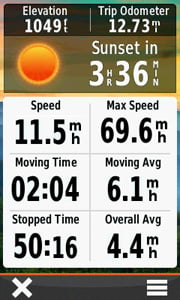 Peningkatan Trip Computer Dapatkan 33 persen lebih banyak data di layar sekaligus dengan opsi tata letak baru. Tambahkan beberapa halaman bidang data, masing-masing dapat disesuaikan ke 1 dari 4 tata letak: 2 besar, 1 besar dan 4 kecil, 6 kecil, atau 8 kecil. Peningkatan Trip Computer Dapatkan 33 persen lebih banyak data di layar sekaligus dengan opsi tata letak baru. Tambahkan beberapa halaman bidang data, masing-masing dapat disesuaikan ke 1 dari 4 tata letak: 2 besar, 1 besar dan 4 kecil, 6 kecil, atau 8 kecil. 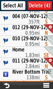 Manajemen Titik Arah Tingkat Lanjut Semua data ditampilkan dan diedit pada 1 layar. Hapus 1 atau beberapa titik jalan sekaligus dari menu Waypoint Manager. Manajemen Titik Arah Tingkat Lanjut Semua data ditampilkan dan diedit pada 1 layar. Hapus 1 atau beberapa titik jalan sekaligus dari menu Waypoint Manager. 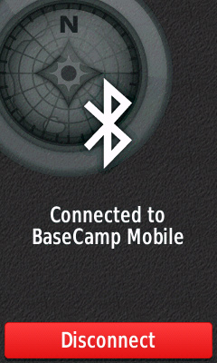 Kemampuan Nirkabel: Bluetooth® dan ANT Kini Anda dapat mentransfer file besar secara nirkabel seperti foto, geocache, petualangan, rute, dan Peta Khusus antara perangkat seri Oregon 600 (atau dengan Garmin Basecamp Mobile ). Selain itu, teknologi baru memungkinkan rute, titik jalan, dan jalur Anda ditransfer hingga 50 kali lebih cepat. Oregon juga kompatibel dengan nirkabel ANT+ untuk sensor detak jantung, irama, kicauan , dan tempe . Kemampuan Nirkabel: Bluetooth® dan ANT Kini Anda dapat mentransfer file besar secara nirkabel seperti foto, geocache, petualangan, rute, dan Peta Khusus antara perangkat seri Oregon 600 (atau dengan Garmin Basecamp Mobile ). Selain itu, teknologi baru memungkinkan rute, titik jalan, dan jalur Anda ditransfer hingga 50 kali lebih cepat. Oregon juga kompatibel dengan nirkabel ANT+ untuk sensor detak jantung, irama, kicauan , dan tempe . 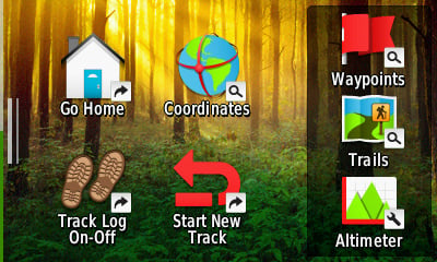 Pintasan Luncurkan aplikasi, ganti Profil, terapkan pengaturan, dan mulai bernavigasi dengan 1 sentuhan. Pintasan Luncurkan aplikasi, ganti Profil, terapkan pengaturan, dan mulai bernavigasi dengan 1 sentuhan. 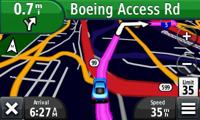 Dasbor/Mode nüvi® Dasbor memungkinkan Anda menyembunyikan dan menampilkan lebih banyak fungsi pada aplikasi favorit Anda. Dengan informasi sekilas ini, Anda dapat melakukan banyak tugas tanpa harus menonaktifkan aplikasi. Dasbor/Mode nüvi® Dasbor memungkinkan Anda menyembunyikan dan menampilkan lebih banyak fungsi pada aplikasi favorit Anda. Dengan informasi sekilas ini, Anda dapat melakukan banyak tugas tanpa harus menonaktifkan aplikasi. |
|
| Spesifikasi | Fisik & Kinerja: Dimensi unit, PxTxD 2,4″ x 4,5″ x 1,3″ (6,1 x 11,4 x 3,3 cm) Ukuran layar, LxT 1,5″W x 2,5″ H (3,8 x 6,3 cm); Diag 3″ (7,6 cm) Tampilan resolusi, LxH 240 x 400 piksel Tipe tampilan warna transflektif Layar sentuh TFT Berat 7,4 oz (209,8 g) dengan baterai Paket NiMH yang dapat diisi ulang baterai (disertakan) atau 2 baterai AA (tidak disertakan); Direkomendasikan NiMH atau Lithium Daya baterai tahan 16 jam Tahan air Ya (IPX7) Mengambang Tidak Penerima sensitivitas tinggi Ya antarmuka USB berkecepatan tinggi dan kompatibel dengan NMEA 0183 Peta & Memori: Peta Dasar Ya Peta yang dimuat sebelumnya tidak kemampuan untuk menambahkan peta Ya Memori internal 3 ,5 GB Menerima kartu data kartu microSDâ„¢ (tidak termasuk) Titik jalan/favorit/lokasi 4000 Rute 200 Log 10.000 titik, 200 jejak tersimpan Fitur & Keuntungan: Perutean otomatis (perutean peningkatan demi peningkatan di jalan) Ya (dengan pemetaan yang inovatif untuk jalan yang terperinci) Elektronik kompas Ya (kompensasi kemiringan 3 sumbu) Layar sentuh Ya Altimeter barometrik Ya Kamera ya (8 megapiksel dengan fokus otomatis; zoom digital) Ramah geocaching Ya (Tanpa Kertas) Kompatibel dengan peta khusus Ya Navigasi foto (menavigasi ke foto yang diberi geotag) Ya Kalender berikutnya/memancing Ya Informasi matahari dan bulan Ya Tabel pasang surut productTemplate.tab.specs.picklist.yes_with_optional_bluechart Penghitungan area Ya POI khusus (kemampuan untuk menambahkan titik menarik tambahan) Ya Transfer unit ke unit (berbagi data secara nirkabel dengan unit serupa) Ya (plus gambar dan peta khusus) Penampil gambar Ya Kompatibel dengan Garmin Connect™ (komunitas online tempat Anda menganalisis, mengkankan, dan berbagi data) Ya Di Dalam Kotak :
|
|---|

Tags: Garmin GPSMap Oregon, Garmin GPSMap Oregon 650, Garmin Indonesia, GPSMap Oregon 650, Oregon 650
Garmin GPS Map Oregon 650
| Berat | 200 gram |
| Kondisi | Baru |
| Dilihat | 485 kali |
| Diskusi | Belum ada komentar |
Produk Terkait
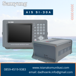
SAMYUNG (Sistem Identifikasi Otomatis) AIS SI-30A Samyung AIS SI-30A adalah peralatan yang berfungsi sebagai Sistem identifikasi otomatis (Automatic Identification System) untuk kapal laut. Peralatan ini membantu kapal mengenali posisi, nama, dan kecepatan kapal lain, sehingga dapat mencegah tabrakan. Automatic Identification System ( AIS ) Samyung SI-30A adalah peralatan yang dibutuhkan setiap kapal laut, untuk memenuhi… selengkapnya
*Harga Hubungi CS
Suplier Alat GPS Beragam tipe yang memudahkan pekerjaan Anda/perusahaan dengan harga yang sangat terjangkau dan kompetitif. Sistem Spectra Precision® EPOCH® 50 GNSS, dengan 220 salurannya, memanfaatkan sinyal GPS L1/ L2/ L2C/ L5 dan GLONASS L1/ L2 secara efektif untuk jangkauan satelit yang luar biasa dan penentuan posisi yang tepat. EPOCH 50 menggunakan teknologi yang telah… selengkapnya
*Harga Hubungi CS
Suplier Alat Survey Beragam tipe yang memudahkan pekerjaan anda/perusahaan dengan harga yang sangat terjangkau dan kompetitif. Dapatkan trackplotting berkualitas dengan GPS 152H sensitivitas tinggi, trackplotter skala abu-abu dengan fitur yang mudah digunakan sesuai dengan perahu dan anggaran Anda. Dapatkan Satelit dengan Cepat GPS 152H dilengkapi dengan penerima GPS sensitivitas tinggi, antena GPS internal, dan konektor… selengkapnya
*Harga Hubungi CS
Spesifikasi Detail GPS Genggam, Kompas 3-sumbu: Resolusi dan Memori Lebih Baik Resolusi lebih besar dengan piksel tampilan 240 x 320 untuk meningkatkan keterbacaan Memori internal menampung untuk menampung lebih banyak peta Peta dasar seluruh dunia dengan relief berbayang Layar 2,2 inci, 65K warna , dapat dibaca di bawah sinar matahari 3- kompas sumbu dan altimeter… selengkapnya
*Harga Hubungi CS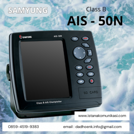
Kelas B AIS-50N Chartpotter AIS 50N Samyung adalah perangkat Automation Identification System (AIS) yang berfungsi untuk menghubungkan dan melacak kapal secara real-time. Perangkat ini memiliki tampilan berwarna yang dapat menampilkan peta laut, posisi kapal, informasi kapal sekitar, dan kedalaman laut. AIS 50N Samyung umumnya digunakan untuk kapal ikan dan kapal di bawah 300GT. Memberikan manfaat… selengkapnya
*Harga Hubungi CS
Suplier Alat Metal Detector Beragam tipe yang memudahkan pekerjaan Anda/perusahaan dengan harga yang sangat terjangkau dan kompetitif. Sistem GPS Trimble® R3 adalah solusi pascaproses GPS L1 lengkap dari pemimpin industri dalam teknologi survei GPS. Menggabungkan penerima dan antena GPS L1, pengontrol yang kokoh, serta perangkat lunak lapangan dan apartemen yang mudah digunakan, sistem Trimble R3… selengkapnya
*Harga Hubungi CS
Suplier Alat GPS Beragam tipe yang memudahkan pekerjaan Anda/perusahaan dengan harga yang sangat terjangkau dan kompetitif. eXplorist Pro10 dengan EZTagCE Kasar dan tahan air untuk kondisi ekstrim Kamera digital, speaker, dan mikrofon terintegrasi Konektivitas nirkabel Bluetooth ke perangkat berkemampuan Bluetooth Penyimpanan memori Kartu Micro SDHC yang dapat diisi Perangkat lunak EZTag CE dengan pengambilan dan… selengkapnya
*Harga Hubungi CS
Suplier Alat GPS Beragam tipe yang memudahkan pekerjaan Anda/perusahaan dengan harga yang sangat terjangkau dan kompetitif. Driver GNSS eXplorist Pro10 + EZSurv Kasar dan tahan air untuk kondisi ekstrim Kamera digital, speaker, dan mikrofon terintegrasi Konektivitas nirkabel Bluetooth ke perangkat berkemampuan Bluetooth Penyimpanan memori Kartu Micro SDHC yang dapat diperluas EZSurv Pasca-pemrosesan memungkinkan akurasi dan… selengkapnya
*Harga Hubungi CS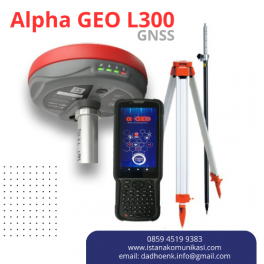
GPS Geodetik GNSS Alpha GEO L300 RTK L300 adalah GNSS Receiver GPS Geodetik RTK pintar generasi baru yang ringkas, dirancang untuk berbagai proyek survei dengan teknologi GNSS terbaru. Perangkat ini dilengkapi dengan semua modul konektivitas modern yang diperlukan, termasuk Bluetooth, radio internal, WiFi, dan modem 4G. Selain itu, L300 juga menggunakan teknologi terbaru seperti baterai… selengkapnya
*Harga Hubungi CS
Suplier Alat GPS Beragam tipe yang memudahkan pekerjaan Anda/perusahaan dengan harga yang sangat terjangkau dan kompetitif. Solusi Rover All-in-one untuk Jaringan RTK ProMark 200 adalah rover RTK jaringan frekuensi ganda yang paling hemat biaya. Solusi ProMark 200 mencakup receiver GNSS Ashtech baru yang kokoh yang menjalankan sistem operasi Windows Mobile® 6.5, perangkat lunak lapangan Ashtech… selengkapnya
*Harga Hubungi CS
Belum ada komentar, buka diskusi dengan komentar Anda.